Partner & Sponsoren


Ebensee - Gmunden INNOTECH half marathon

 Description of the route
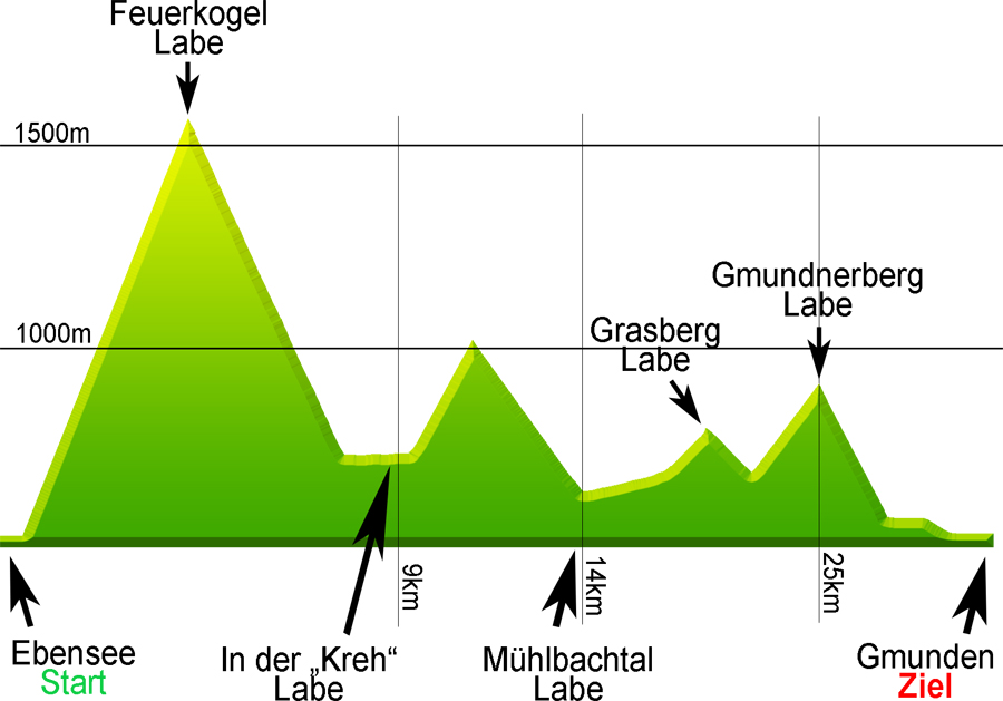
This half mountain marathon will take you from the starting point in Ebensee (the town hall square), over the Kalvarienberg mountain and along the hiking trail to the Kranabethhütte lodge (formerly called the "Naturfreundehaus") on the Feuerkogel mountain plateau. From the Feuerkogel plateau, you will head north and down into the Langbath valley until you reach the "Kreh" refreshment point. You will then continue on the hiking trail towards Hochsteinalm before heading back down through woodland and along meadow paths into the Mühlbach valley and to the Mühlbach refreshment point. The "Horn" agricultural road will take you up the Grasberg mountain. From there, you will continue along the hiking trail that will take you up the Gmundnerberg mountain and what used to be the Naturfreundehaus. You will then descend via the hiking trail and proceed along the Gmunden esplanade until you reach the finish line.
| Start: Ebensee Any time between 8.30 a.m. and 9 a.m. |
Finish: Gmunden town hall square Finish line closes at 9 p.m. |
Route data: Approx. 34 km / elevation gain of approx. 2000 m
Issue of bib numbers:
- Gmunden (mountain marathon marquee in town hall square)
Friday 06 July 2018:
2 p.m. – 8 p.m. Bib numbers to be issued for all routes
Refreshment points:
It will be possible to stop at the various lodges and inns (Feuerkogel, Kreh, Gmundnerberg) so please remember to bring some cash with you.
The routes and the marked tracks will be checked in cooperation with Race Results.
Altitude diagram and refreshment points
Time limits:
|
|
The data has been measured with GPS and edited using cartographic software. The results may deviate from the actual situation because of inaccuracies linked to the nature of the system and the environment. All information is supplied "as is" without warranty of any kind.
Last-minute changes may be made to the route, the checkpoints and the refreshment points at any time.
Please refer to "freytag & berndt" walking map 5503 as an orientation guide. This is the map on which the description of the route is based.