Partner & Sponsoren


OSP 22 Gmunden - Gmunden mountain marathon

Description of the route:
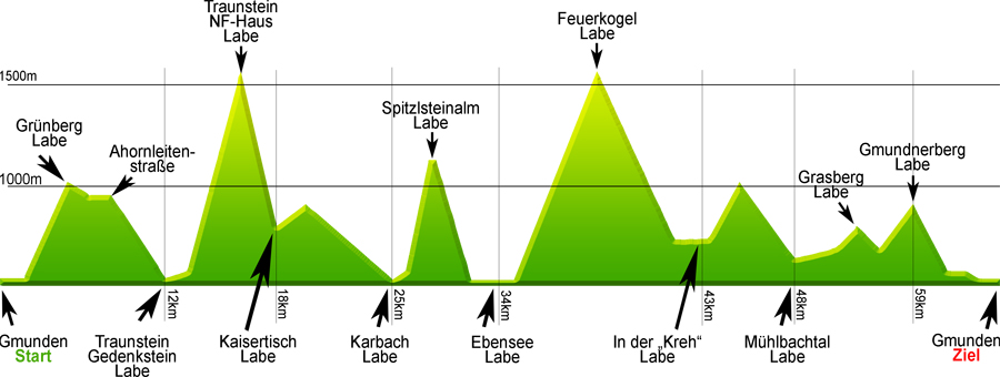
 The OSP 22 mountain marathon will take you from the starting point (Gmunden town hall square), over the Traunbrücke bridge, and up the steep Ortnersteig track to the Grünberg mountain. You will then continue to Radmoos on the Waldlehrweg path before heading west along forest tracks until you reach the start of the Naturfreundesteig (a steep alpine track!). This will take you up to the Naturfreundehaus mountain hut on the Traunstein mountain and from there you will follow the Mair-Alm track down to Kaisertisch. You will then continue on forest tracks to Karbach and along the eastern shore until you reach the Daxnersteig (another steep alpine track!). You will follow this up to Spitzelsteinalm and then head back down to a place called Rindbach via the hiking trail. The next part of the route leads to the refreshment point in Ebensee town hall square and then over the Kalvarienberg mountain and along the hiking trail to the Kranabethhütte lodge (formerly called the "Naturfreundehaus") on the Feuerkogel mountain plateau. From the Feuerkogel plateau, you will head north and down into the Langbath valley until you reach the "Kreh" refreshment point. You will then continue on the hiking trail towards Hochsteinalm before heading back down along meadow paths into the Mühlbach valley and to the Mühlbach refreshment point. The "Horn" agricultural road will take you up the Grasberg mountain. From there, you will continue along the hiking trail that will take you up the Gmundnerberg mountain and what used to be the Naturfreundehaus. You will then descend via the hiking trail and proceed along the Gmunden esplanade until you reach the finish line.
| Start: Gmunden town hall square Any time between 3 a.m. and 5 a.m. |
Finish: Gmunden town hall square Finish line closes at 9 p.m. |
Route data: Approx. 70 km / elevation gain of approx. 4500 m
Issue of bib numbers:
- Gmunden (mountain marathon marquee in town hall square)
Friday 6 July 2018:
2 p.m. – 8 p.m. Bib numbers to be issued for all routes
Refreshment points:
It will be possible to stop at the various lodges and inns (Traunstein, Karbach, Feuerkogel, Kreh, Gmundnerberg) so please remember to bring some cash with you.
The routes and the marked tracks will be checked in cooperation with Race Results.
Ahornleitenstraße checkpoint:No refreshments
Traunstein checkpoint: Water only
Altitude diagram and refreshment points
Time limits:
|
|
The data has been measured with GPS and edited using cartographic software. The results may deviate from the actual situation because of inaccuracies linked to the nature of the system and the environment. All information is supplied "as is" without warranty of any kind.
Last-minute changes may be made to the route, the checkpoints and the refreshment points at any time.
Please refer to "freytag & berndt" walking map 5503 as an orientation guide. This is the map on which the description of the route is based.